
Parcel 05-3N-24-2020-0010-0000
Owners
P O BOX 1392
HILLIARD, FL 32046
Parcel Summary
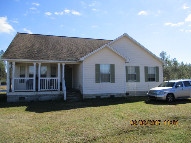
| Situs Address | 271451 GEORGIA ST |
|---|---|
| Use Code | 0100: SINGLE FAMILY |
| Tax District | 3: Hilliard |
| Acreage | 10.000 |
| Section | 5 |
| Township | 3N |
| Range | 24 |
| Subdivision | |
| Exemptions | HX: Homestead (196.031(1)(a)) (100%) HB: Homestead Banded (196.031(1)(ab) (100%) |
Short Legal
LOT 10IN OR 1207/1987
CORNWALL SURVEY
Values
| 2025 Certified Values | 2026 Preliminary Values | |
|---|---|---|
| Land Value * | $195,000 | $190,000 |
| (+) Improved Value | $179,523 | $187,469 |
| (=) Market Value | $374,523 | $377,469 |
| (-) Agricultural Classification | $0 | $0 |
| (-) SOH or Non-Hx* Capped Savings ** | $203,935 | $202,275 |
| (=) School Assessed Value | $170,588 | $200,194 |
| County Assessed Value | $170,588 | $175,194 |
| (-) School Exemptions | $25,000 | $50,000 |
| (-) Non-school Exemptions | $50,722 | $51,411 |
| (=) School Taxable Value *** | $145,588 | $150,194 |
| (=) County Taxable Value | $119,866 | $123,783 |
Document/Transfer/Sales History
| Instrument / Official Record | Date | Q/U | V/I | Sale Price | Grantor | Grantee |
|---|---|---|---|---|---|---|
| WD 1207/1987 | 2004-02-12 | U | Vacant | $100 | CENTER JORDAN K & EDMOND WARGO | MCDONALD CHRISTOPHER |
| WD 1195/0511 | 2003-12-15 | Q | Vacant | $77,500 | CENTER JORDAN K & EDMOND WARGO | MCDONALD CHRISTOPHER |
| WD 1078/0131 | 2002-08-30 | Q | Vacant | $55,000 | BROCK MAXINE | CENTER JORDAN & EDMOND WARGO |
| WD 0936/0125 | 2000-06-12 | U | Vacant | $2,428 | SUNTRUST BANK TRUSTEE | BROCK MAXINE |
| WD 0910/1897 | 1999-12-10 | Q | Vacant | $24,500 | SUNTRUST BANK TRUSTEE | BROCK MAXINE |
| QC 0892/0550 | 1999-07-22 | U | Vacant | $100 | DINKINS THEO EST | SUNTRUST BANK TRUSTEE |
| QC 0892/0543 | 1999-07-22 | U | Vacant | $100 | DINKINS THEO EST | SUNTRUST BANK TRUSTEE |
Buildings
Building # 1
| Heated Sq Ft | Year Built | Value |
|---|---|---|
| 1738 | 2006 | $187,469 |
Land Lines
Personal Property
None
TRIM Notices
Property Record Cards
Disclaimer
The Nassau County Property Appraiser's Office makes every effort to produce the most accurate information possible. No warranties, expressed or implied, are provided for the data herein, its use or interpretation. The information contained herein is for ad valorem tax assessment purposes only. The Property Appraiser exercises strict auditing procedures to ensure validity of any transaction received and posted by this office but cannot be responsible for errors or omissions in the information received from external sources. Due to the elapsed time between transactions in the marketplace, and the time that those transactions are received from the public and/or other jurisdictions, some transactions will not be reflected.